

“Iran holds a lot of cards with the Strait of Hormuz.” — Justin Wolfers
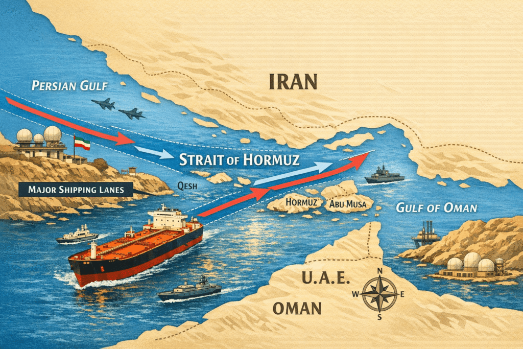
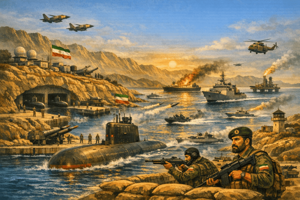
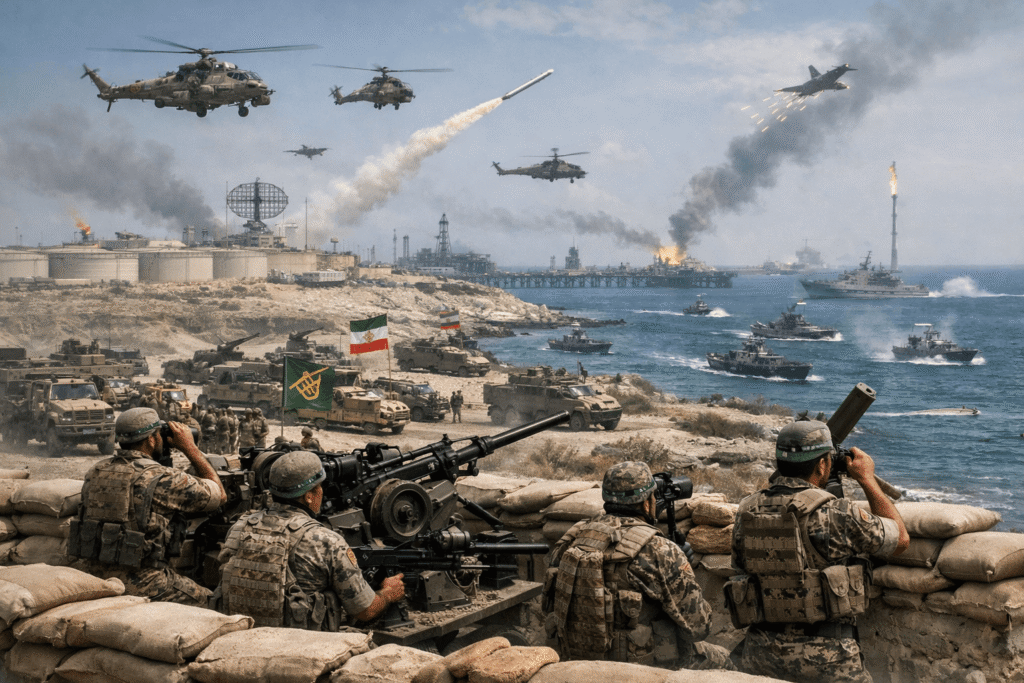
The geographical configuration of the Persian Gulf is characterised by narrow passages and strategically significant islands. The nature of conflict in this region has evolved from conventional naval engagements into a multifaceted contest involving advanced technologies and subterranean infrastructure. Key islands such as Kharg, Qeshm, Abu Musa, the Tunbs, and Larak are strategically important to Iran. These islands help Tehran maintain influence over a major energy corridor and complicate adversarial attempts to dominate the Strait of Hormuz.
Kharg Island
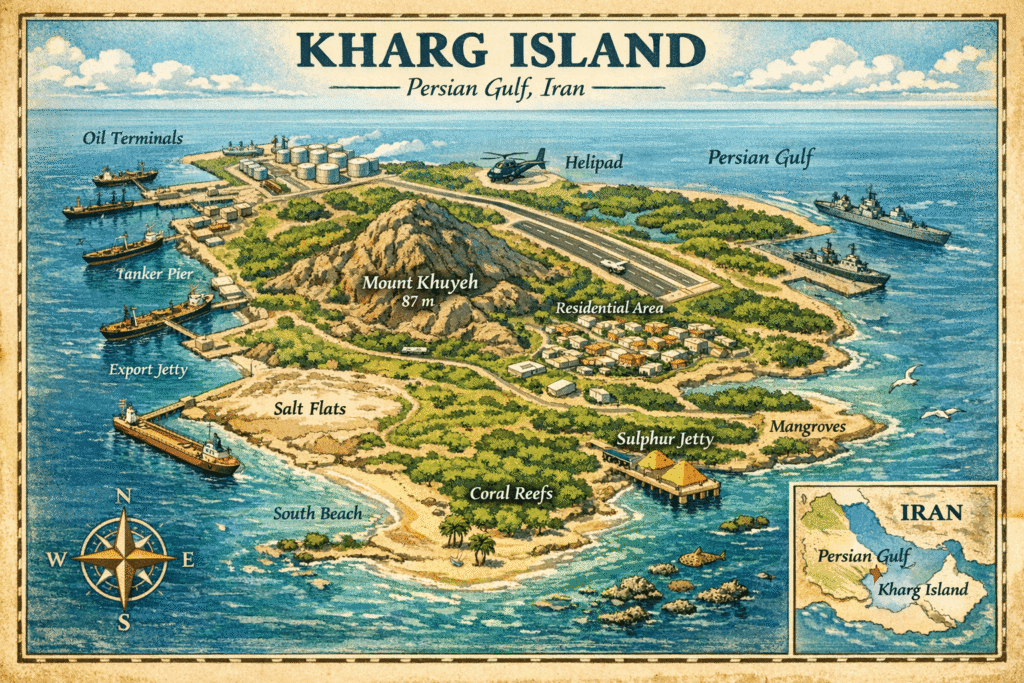
Kharg Island is particularly vital to Iran’s economy. Situated in the northern Persian Gulf, it serves as the primary hub for exporting nearly 90 per cent of Iran’s oil. Despite its modest size, the island possesses deep waters capable of accommodating large vessels and has the capacity to load approximately 7 million barrels of oil daily. Located 34 miles northwest of Bushehr, Kharg Island is endowed with natural freshwater resources, a rarity in the Gulf region, which has supported sustained human habitation and activity.
The availability of freshwater distinguishes Kharg Island from other arid Gulf islands, enabling a substantial population and workforce to reside there. This, in turn, supports a significant military presence and complex industrial operations that smaller islands cannot sustain. Presently, it houses 55 oil storage tanks with a combined capacity exceeding 34 million barrels.
Iran regards Kharg as a vital strategic asset, characterised by robust and multilayered defences. The 112th Zolfaghar Surface Combat Brigade of the Islamic Revolutionary Guard Corps Navy (IRGCN) collaborates with the regular army to strengthen these defences. This year, Iran augmented these fortifications to thwart potential ground assaults. Reports indicate the presence of numerous anti-personnel and anti-tank mines along the coastline, particularly in areas susceptible to amphibious landings.
The defence strategy for Kharg emphasises subterranean fortifications. Iranian forces have therefore constructed an extensive underground network to ensure the continuous flow of oil and safeguard weaponry during aerial attacks. This network includes fortified shelters for fast-attack boats and missile batteries that can be swiftly deployed for combat and then withdrawn into the island’s interior for protection.
The island hosts the 112th Zolfaghar Brigade, which specialises in fast-attack craft for asymmetric harassment. Its coastal batteries include Nasr-1 and Kowsar missile systems, which provide short-range anti-ship defence up to 25 km. It also has early-warning and tracking Ghadir radar systems with a range of 1,100 km. Its air defences include S-300 systems and mobile batteries to counter cruise missiles and strike aircraft, along with underground storage bunkers for the protection of munitions and mines from air strikes.
In March 2026, United States airstrikes targeted military installations on Kharg Island, focusing specifically on sites storing sea mines and missiles intended to obstruct the Strait. These strikes deliberately avoided oil export areas to maintain economic stability and avert a global energy crisis. From the perspective of an aggressor, seizing control of Kharg Island offers “coercive leverage” without necessitating an invasion of the mainland. By capturing the island, a foreign power could exert control over Iran’s oil revenues, effectively placing the regime on a “ration card” system.
This strategy presupposes that control of a critical location can influence Tehran’s actions without a comprehensive mainland campaign. However, the military risks are substantial. U.S. experts assert that Iran’s defences, including minefields and missile batteries, would make any assault “extremely bloody”. The White House acknowledges that capturing Kharg would damage Iran’s economy, but would not prevent the IRGC from continuing operations from other Gulf bases.
Qeshm Island
Although Kharg serves as an economic hub, Qeshm Island is pivotal to Iran’s naval strategy. As the largest island in the Persian Gulf, it commands the entrance to the Strait of Hormuz. Its geographical features, including salt caves, mangrove forests, and rugged terrain, conceal “underground missile cities”. Qeshm functions as a “cork” in the Strait. From its southern shores, Iranian forces can monitor and potentially intercept all maritime traffic entering or exiting the Gulf.
The island’s proximity to the mainland, a mere 22 km from Bandar Abbas, facilitates a continuous flow of supplies and reinforcements, complicating efforts to isolate it through a naval blockade. Qeshm Island serves as an “unsinkable aircraft carrier” and missile hub. Its considerable size provides strategic depth. Unlike smaller islands, it cannot be easily neutralised through aerial bombardment. It also possesses the capacity for essential survival infrastructure, such as desalination plants and power generation facilities, which are vital for sustained resistance.
The “missile cities” located in Qeshm represent extensive subterranean networks designed to endure aerial assaults. These facilities house various armaments, including:
- mobile coastal launchers capable of deploying Ghader cruise missiles with a range of 200–300 km and Abu Mahdi cruise missiles with a range exceeding 1,000 km;
- concealed fast-attack craft positions, where tunnels enable the rapid ingress and egress of IRGCN speedboats into shipping lanes, thereby evading detection by drones and satellites; and
- command-and-control nodes, which are fortified centres utilising data from drones and radars to provide comprehensive maritime situational awareness.
The strategic objective of these “missile cities” is to exert control over, or obstruct, the Strait of Hormuz. This capability was demonstrated recently when Iran halted maritime traffic following threats to attack any vessel attempting passage.
The March 2026 escalation underscored Qeshm’s military significance when U.S. airstrikes targeted a desalination plant on March 7, 2026, disrupting the water supply to 30 adjacent villages. This action was presumably intended to pressure the IRGC by affecting the island’s logistical support system for both military personnel and the civilian population. In response, the IRGC swiftly retaliated against U.S. forces stationed in Bahrain, asserting that the assault on Qeshm had originated from a nearby Gulf state.
For adversaries, Qeshm constitutes a critical target, as its capture is perceived as essential to dismantling Iran’s dominion over the Persian Gulf. However, with a population of 148,000 and an intricate underground infrastructure, an invasion would pose significant challenges. The island is frequently described as an “unsinkable aircraft carrier” because of its formidable defences.
The Nazeat Islands
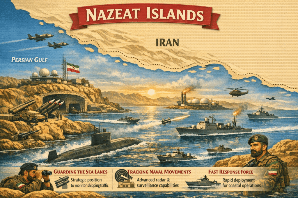
Abu Musa and the Tunbs serve as Iran’s primary maritime defence line, and their strategic location near the narrowest segment of the Strait of Hormuz enhances their importance. Although the United Arab Emirates lays claim to these islands, Iran has maintained control over them since November 30, 1971. The dispute over these islands predates the establishment of the UAE. In 1971, as British forces withdrew, the Shah of Iran ordered the navy to seize the islands to prevent their transfer to the nascent UAE.
Since then, Iran has expanded its military presence on the islands and has not consented to international arbitration. The UAE characterises this as an “illegal occupation”, which remains a core issue in the Gulf Cooperation Council’s foreign policy.
The Nazeat Islands are vital for Iran’s maritime control. Large oil tankers navigate between Abu Musa and the Tunbs, making these islands significant for monitoring and controlling maritime traffic. The islands are equipped with:
- advanced sensor arrays, including radar and other sensors for efficient ship tracking;
- electronic warfare suites, capable of disrupting GPS signals and reportedly affecting over 1,000 commercial ships since February 2026; and
- missile and drone launch pads, including hardened silos for missiles and pads for drones.
Recent satellite imagery indicates that U.S. strikes have inflicted “substantial damage” on military facilities on the Nazeat Islands. On Greater Tunb, 14 structures, including the main airfield hangar and fuel depots, sustained heavy damage or were destroyed. These strikes were aimed at weakening facilities that support underground bunkers storing missiles and mines threatening the Strait.
From the perspective of an aggressor or GCC coalition, seizing the Nazeat Islands is seen as a way to alter the balance with Tehran. By deploying coalition forces on these islands, they could protect shipping rather than threaten it. Tehran, however, has warned that any attack launched from UAE territory on these islands would invite “direct and devastating strikes” on Ras Al Khaimah.
Larak Island
Larak Island is situated at the narrowest point of the Strait of Hormuz, giving it a strategic advantage. It is equipped with bunkers and attack craft for close combat in the Strait. Iranian gunboats frequently approach commercial vessels to inspect documents or redirect them. Vessels must navigate close to Larak’s coast, enabling Iran to exercise control over traffic. Securing control of Larak is essential to dismantling Iran’s grip on maritime traffic, but the island is heavily fortified and would pose a significant risk for any invading force.
Sirri and Lavan
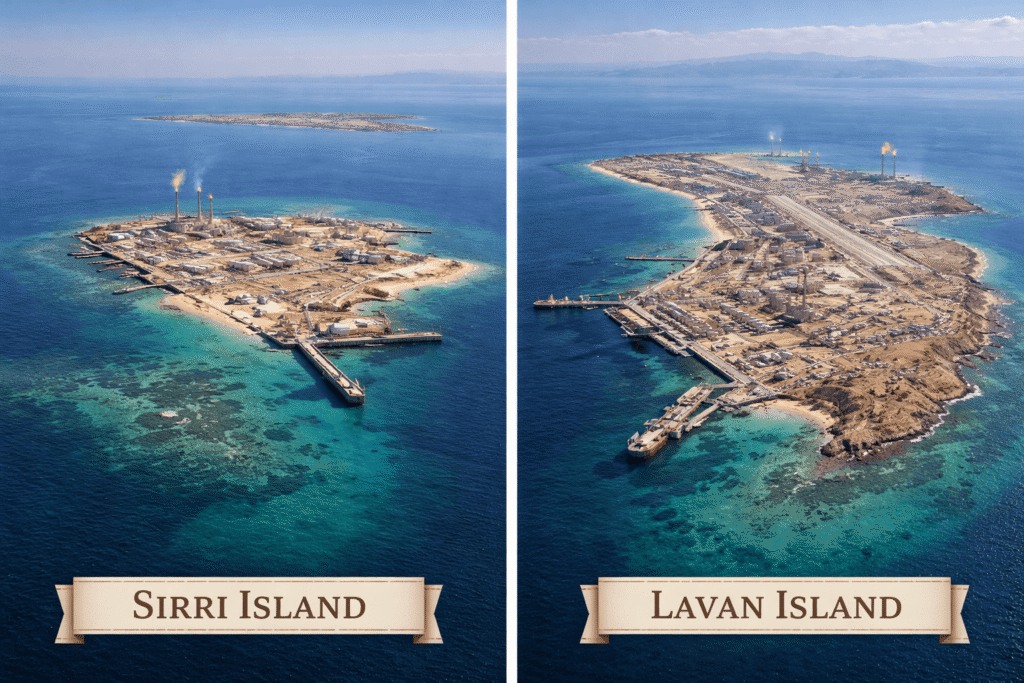
Sirri and Lavan Islands serve as critical backup centres for oil and naval operations. During the Iran-Iraq War, when Kharg Island was subjected to intense Iraqi attacks, Iran strategically shifted much of its shipping activity to these islands. Today, they continue to play a crucial role in supporting the IRGCN’s “mosquito fleet” strategy.
In 1988, during Operation Praying Mantis, the United States Navy targeted and destroyed the Sirri oil platform because it was being used by Iranian forces to attack tankers. In the current conflict, these islands remain significant targets, used for deploying fast boats and serving as observation points to monitor the southern Gulf.
Iranian Naval Doctrine
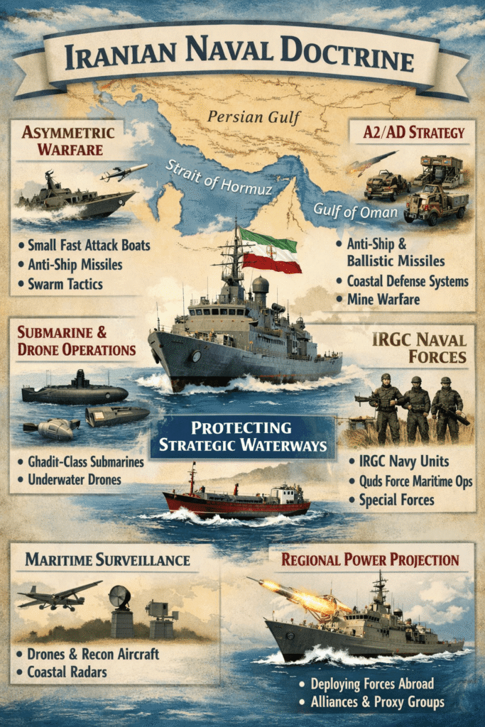
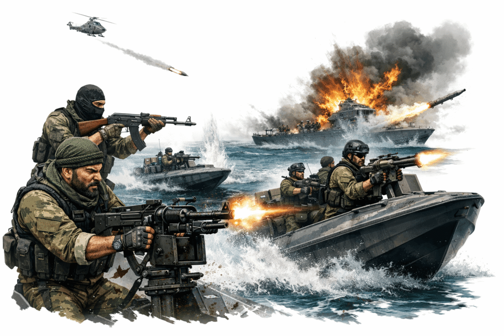
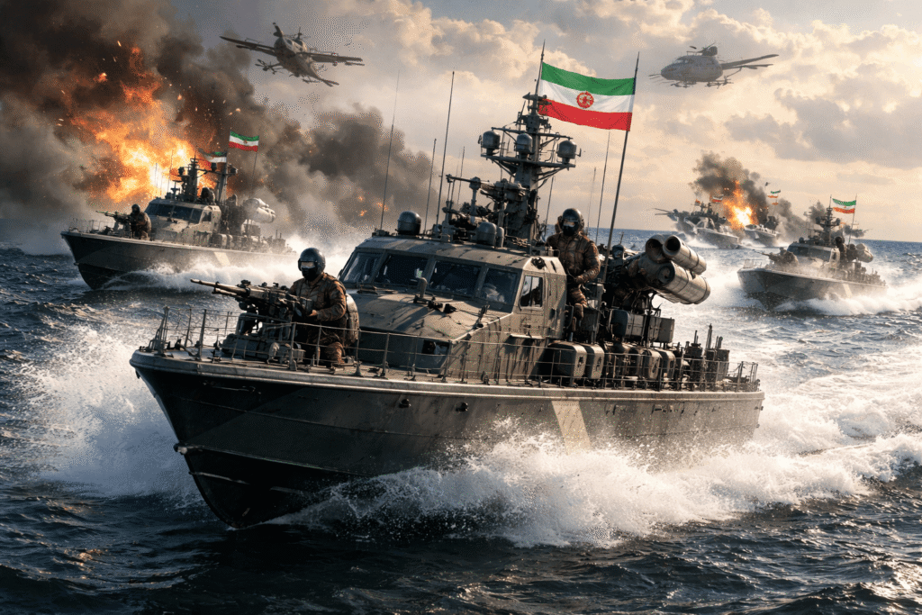
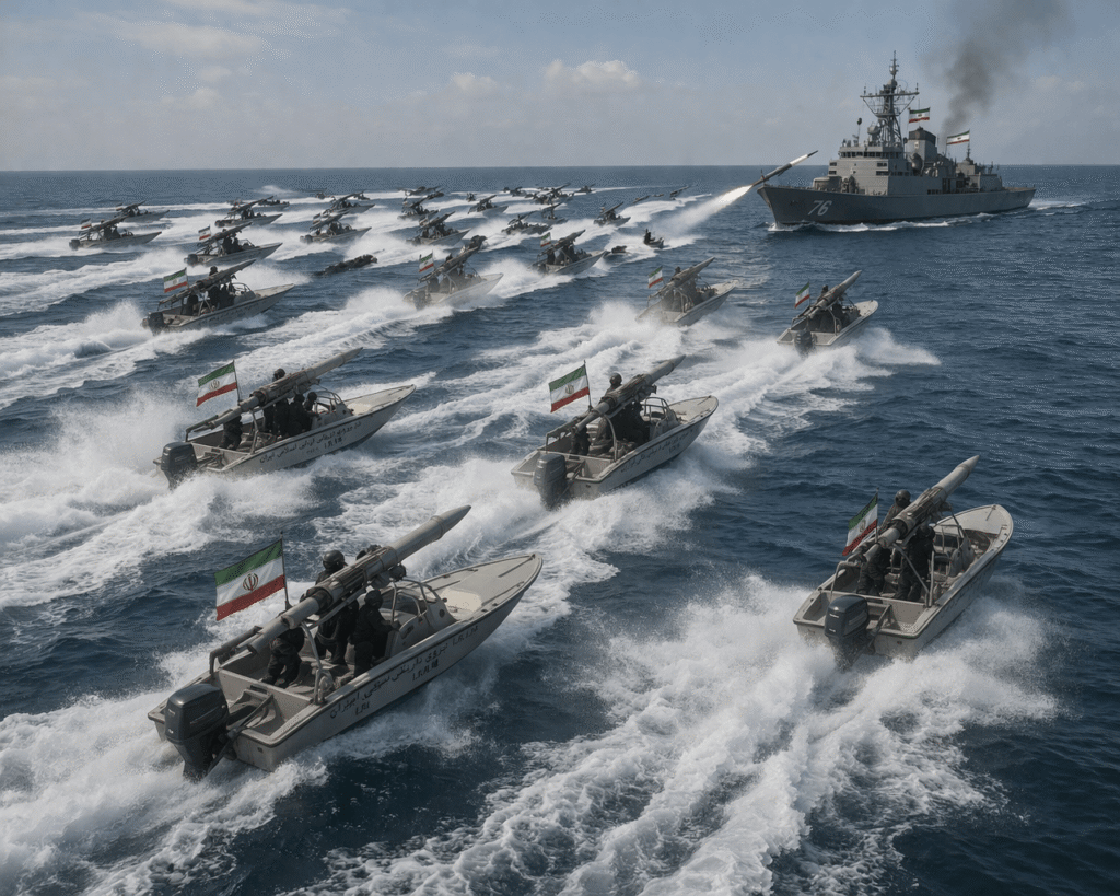
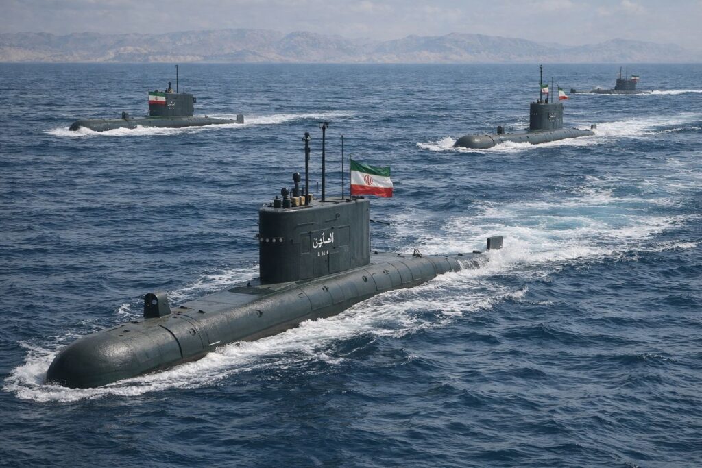
The core of Iran’s naval capability lies with the IRGCN, established in 1985 to conduct asymmetric warfare in coastal regions. This strategy, known as the “mosquito fleet” approach, relies on numerous small, fast, and agile vessels to challenge more powerful adversaries. The mosquito fleet comprises more than 1,500 small attack boats, many of which weigh less than 10 metric tons.
These vessels are designed for high-speed, asymmetric swarm warfare and can achieve speeds ranging from 50 to 110 knots, complicating the response efforts of larger warships.
Attack Boat Classifications
Heydar-110: The Heydar-110 is a carbon-fibre catamaran capable of reaching speeds of 110 knots and equipped with two Nasr-1 missiles. Introduced in March 2026, it represents a significant advancement, as it can attain speeds of 204 km/h, making it difficult to intercept using conventional ship systems. In the constrained waters of the Gulf, these boats can conceal themselves, execute rapid attacks, and withdraw before the adversary can respond.
Zulfiqar-class: Designed for escort and missile-strike operations, these vessels can achieve speeds of 50–70 knots. They are armed with short-range surface-to-air missiles and anti-ship missiles.
Sina-class: Fast attack craft serving as guided-missile platforms.
Seraj-1: A high-speed interceptor capable of exceeding 60 knots, armed with rockets and heavy machine guns.
Swarm Tactics and Economic Asymmetry
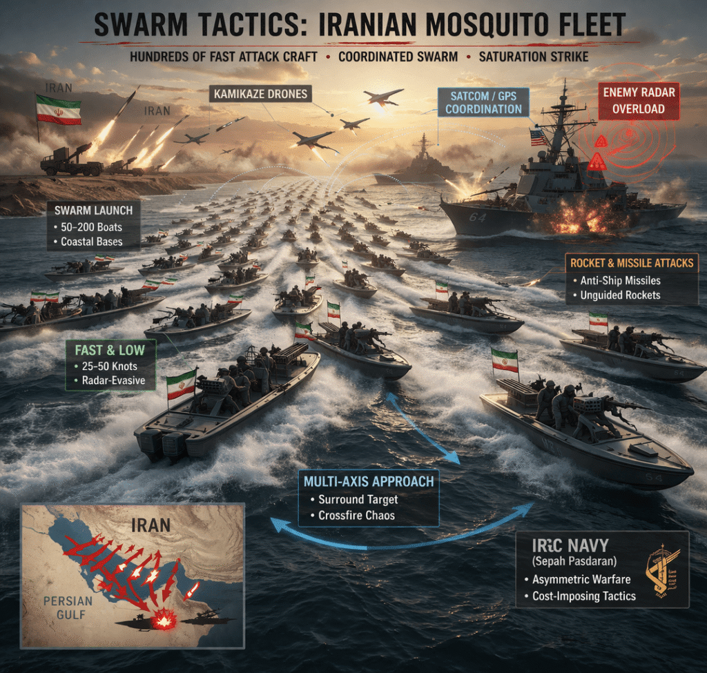
The Iranian mosquito fleet is integral to Iran’s anti-access/area-denial strategy. Swarm tactics compel U.S. destroyers to engage their radar and fire-control systems against multiple targets, creating an “economic asymmetry” in which a defender may expend a $2 million interceptor to neutralise an inexpensive speedboat or drone.
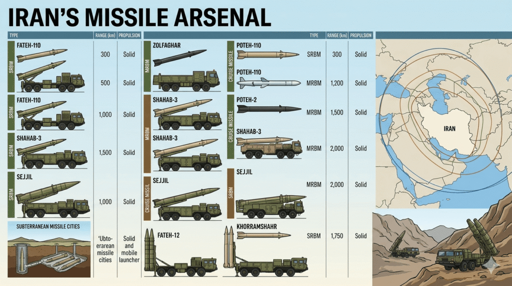
Iran’s missile arsenals and coastal defence systems also compel other navies to remain either far offshore or under constant radar surveillance. This Iranian architecture integrates short-, medium-, and long-range missiles into a single AI-supported network. Short- and medium-range missiles, such as the Nasr and Kowsar, can strike targets up to 25 km away, making them ideal for targeting tankers within the narrow lanes of the Strait. The Ghader missile, with a range of 200–300 km, enables coastal batteries to target naval groups near the Gulf’s entrance.
The Abu Mahdi long-range cruise missile has reportedly been produced in significant quantities since 2023 and plays a crucial role in Iran’s defence strategy. This missile can strike targets more than 1,000 km away, including U.S. military bases in Qatar and Bahrain. It uses artificial intelligence to maintain a low-altitude flight path over the sea, thereby reducing its radar cross-section. It is equipped with both active and passive target-acquisition modes, enabling it to locate and track targets even in complex electronic warfare environments. It is also designed to evade countermeasures.
Since January 2025, mobile launchers have reportedly been distributed to IRGC units. Their mobility makes them difficult to detect and target.
Subsurface Warfare
In the shallow waters off the Strait of Hormuz, Iran’s small submarines have demonstrated greater operational utility than larger nuclear submarines. The Ghadir, a 29-metre-long submarine, can operate in waters as shallow as 30 metres. These submarines are used for the clandestine deployment of mines and torpedoes, such as the Valfajr and Hoot.
The larger Fateh-class 600-ton submarines are equipped with advanced sensors for operations in deeper waters. The first of this class, IRIS Fateh, was reportedly lost during the current conflict, although additional units are also said to remain operational.
The mine threat
Experts assert that Iran’s mine-laying capabilities pose a significant threat. Since the onset of the conflict, Iran has deployed at least a dozen Maham 3 and Maham 7 mines in the Strait. Mine-clearance operations are slow and hazardous, and they can disrupt maritime traffic for weeks, especially since minesweepers themselves remain vulnerable to attacks from nearby artillery.
Unmanned and Autonomous Systems
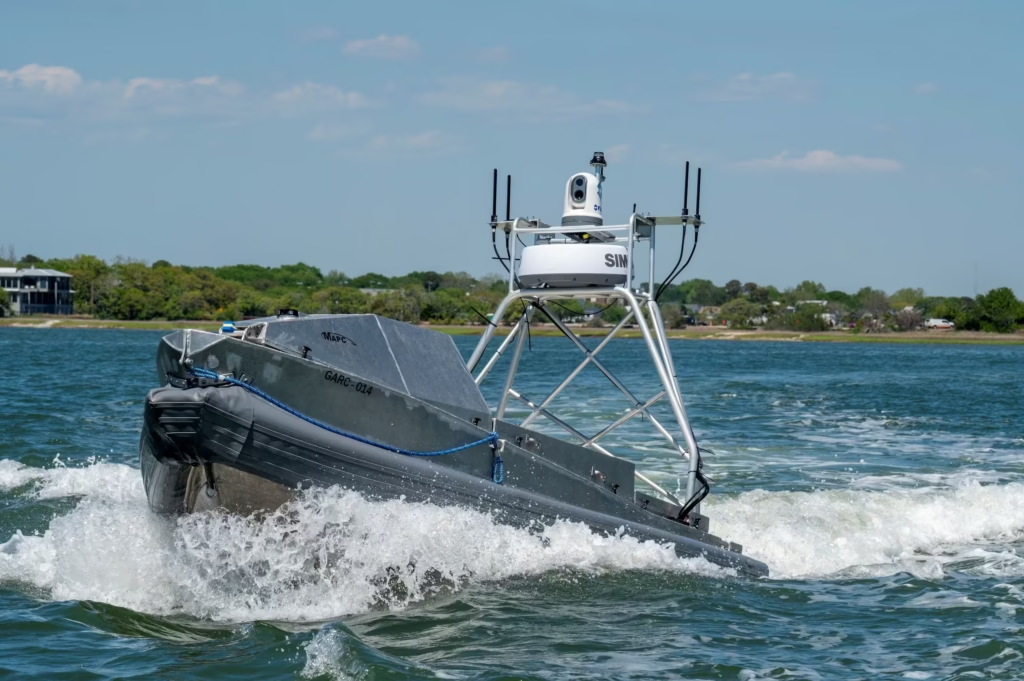
The current conflict has marked a pivotal moment in naval warfare, characterised by the large-scale deployment of kamikaze unmanned surface vessels in the Persian Gulf for the first time.
Iranian USV and drone capabilities
The IRGCN has deployed various types of drone boats, including the Seadog, Ghaton, and Saegheh, reportedly leveraging technology from Ukraine and Houthi rebels. These vessels, which carry 100–500 kg of explosives, are guided by GPS, radar, or artificial intelligence. These include:
- Seadog / Ghaton: a surface USV with a speed of more than 50 knots and a range of around 200 km, equipped with GPS, radar, and AI guidance;
- Saegheh: different surface USV variants with speeds of more than 40 knots, a range of around 150 km, and GPS-cum-remote guidance;
- Azhdar UUV: a torpedo drone with speeds of 18–25 knots and a range of more than 600 km, powered by lithium batteries. Its silent operation makes it difficult to detect amid the ambient noise of Gulf waters, allowing it to approach critical targets and detonate in proximity; and
- Shahid Bagheri: a 40,000-ton ship converted into a drone carrier, with a speed of more than 20 knots and a range of 22,000 nautical miles, capable of launching drone swarms and missiles. It allows Iran to project power far from its coastline without refuelling. However, it has reportedly been severely damaged in the current conflict.
The Electronic Battlefield and the Sino-Iranian Nexus

The conflict of 2026 is characterised by an increasing reliance on artificial intelligence and a robust technological partnership between Iran and China. China is said to be assisting Iran through the China Electronics Technology Group Corporation, facilitating the transition of Iran’s military from reliance on American GPS to the Chinese BeiDou-3 system.
- Decoy and deception: Chinese enterprises have reportedly developed systems capable of emitting deceptive signals that mimic oil tanker movements, thereby obscuring genuine military operations and misleading adversarial surveillance with false data.
- Digital twins: CETC is said to employ sophisticated simulations of maritime movement and environmental conditions, allowing Iranian commanders to test and modify attack strategies in real time using surveillance inputs.
- Unified command: AI systems integrate satellite, drone, and radar data into a cohesive framework, reducing confusion and enhancing the precision of missile guidance.
U.S. AI-enabled targeting

The U.S. military reportedly employs the Maven Smart System for targeting operations in Iran. However, the use of AI in targeting has raised ethical and operational concerns, particularly following a strike on a school in Minab that resulted in 168 casualties.
Electronic warfare and signal spoofing
Since February 2026, the Persian Gulf has experienced sophisticated electronic interference affecting both military and commercial vessels.
- U.S. jammers reportedly use AI-driven beams to incapacitate Iranian radar, creating “invisible electronic bubbles” that prevent missiles from targeting coalition aircraft.
- Tehran has reportedly disrupted GPS signals used by critical U.S. platforms, such as RC-135 Rivet Joint aircraft and MQ-9 Reaper drones, forcing them to rely on backup systems.
Geopolitical Toll Booth
As of late March 2026, the Strait of Hormuz appears to be entering a new phase of Iranian control rather than a complete blockade. Through what may be described as a Hormuz “toll booth” and selective passage arrangement, Iran has implemented a “selective transit model”, allowing “non-hostile” vessels to traverse the Strait subject to coordination with Iranian authorities.
Vessels are required to navigate a designated route north of Larak Island, within Iranian territorial waters. Vessels associated with the United States, Israel, or other identified “aggressors” are denied safe passage. Certain vessels, such as Chinese state-owned tankers, are said to have made payments to the Islamic Revolutionary Guard Corps for secure transit through the Strait.
Oman and alternative routing
Oman has emerged as a pivotal player in regional trade, with ports such as Salalah and Sohar handling cargo that cannot access the Gulf directly. A “green corridor” was established in March 2026 to facilitate the overland movement of goods from Omani ports to the United Arab Emirates, Saudi Arabia, and Kuwait, thereby bypassing threatened naval zones.
Assessment of Relevance and Future Outlook
The strategic configuration of the Persian Gulf islands in 2026 marks a substantial shift in maritime control. Dominant naval power alone no longer guarantees superiority in narrow theatres where geography favours coastal actors using advanced technology and hardened infrastructure.
The ongoing U.S.-Israeli air campaign has resulted in the destruction of several significant Iranian naval assets, including the IRIS Makran and more than 154 smaller vessels. Yet the threat persists. The mosquito fleet and mobile missile batteries remain formidable, drawing strength from the strategic depth of islands such as Qeshm and the fortified bunkers of the Nazeat Islands.
Strategic Conclusions
Geography as a weapon: The narrow and shallow Strait of Hormuz constitutes Iran’s principal strategic advantage. Efforts to secure it through conventional means alone could produce heavy casualties and disrupt the global economy.
The AI escalation: The integration of artificial intelligence into targeting and navigation has accelerated military decision-making, but it has also introduced the risk of errors and civilian casualties.
Economic coercion versus total war: The U.S. strategy of targeting Kharg Island seeks to exert financial pressure on the regime rather than secure outright military defeat. Its success depends on precise execution and on preventing Iran from reaching a point of complete economic desperation.
The new maritime order: The selective-transit model suggests that the future of the Strait may involve managed pathways and geopolitical alignment rather than unrestricted navigation.
The islands of the Persian Gulf have become integral to a broader strategic design aimed at shaping the global economy. As the conflict continues, these islands are likely to assume even greater significance. They will serve both as a testing ground for contemporary naval strategy and as a measure of the resilience of the international energy supply chain.
Current Status
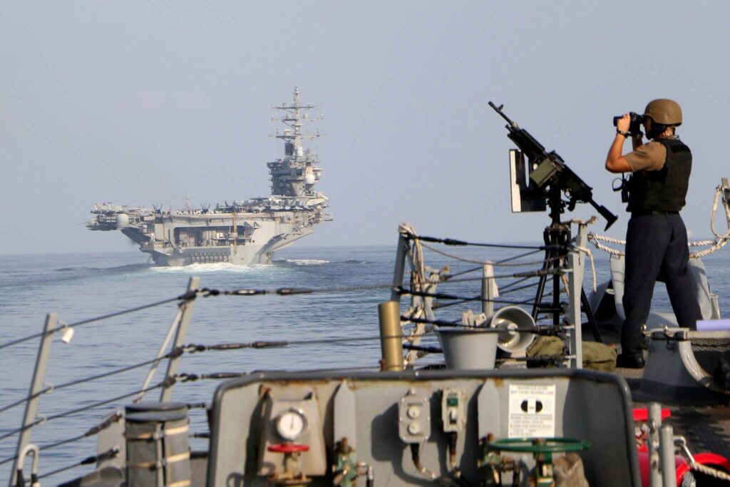
The United States has deployed two carrier strike groups to the region in conjunction with Israeli forces, indicating the potential for operations beyond air strikes alone. The U.S. Marine Corps is concentrating on littoral combat, with a possible focus on specific islands. The operation, termed “Multi-Island Gambit”, is intended to undermine Iran’s defences by seizing strategic islands.
Key targets: Abu Musa and the Tunbs
Historically, naval assaults have failed without ground support. Consequently, the coalition intends to neutralise Iran’s air defences in order to prevent reinforcements. It is likely to employ advanced tactics, including helicopters and stealth aircraft, to circumvent mines and secure the islands.
Strategic target: Kharg Island
Kharg is heavily fortified with mines, requiring a substantial force, including airborne troops and coastal security elements, for its capture. The coalition would probably seek to leverage artificial intelligence to identify and target Iranian defences rapidly, with support from Israeli and GCC air forces.
Qeshm and Larak Islands
Qeshm Island has a population of around 150,000, making a full-scale occupation improbable. Instead, Qeshm and Larak may be subjected to targeted assaults on strategic locations and sustained aerial bombardment. Larak’s proximity to the narrow Strait makes troop deployment there highly risky unless adjacent waters are fully secured. Coalition forces may therefore employ unmanned surface and underwater vehicles to blockade Larak and monitor its missile installations.
Crystal Gazing
The coalition is likely to adopt a phased island-hopping strategy adapted to contemporary warfare. It may first move swiftly to seize Abu Musa and Greater Tunb using marine littoral teams in order to establish a secure corridor for minesweeping operations. It could then launch a more substantial offensive on Kharg Island, potentially deploying the 82nd Airborne Division to secure the oil terminals before they are damaged.
This strategy draws directly on the geography of the islands as a defensive system. By dominating them, the coalition would establish a defensive perimeter in the Gulf, thereby preventing the IRGC from launching attacks using unmanned vehicles, mines, and small boats that currently threaten movement through the Strait.
Still hoping for peace to prevail at the earliest.
“It is not enough to win a war; it is more important to organise the peace.” — Aristotle
A very comprehensive analysis of the unique fortified naval corridor which holds the entry to the world’s prized oil treasure.